

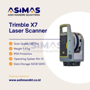
Trimble X7 Laser Scanner

Trimble X7 Laser Scanner alat keren yang kompak dan ringan banget. Ada fitur-fitur canggih
kayak kalibrasi otomatis dan registrasi lapangan yang bikin hidup surveyor jadi lebih simpel, efisien, dan penuh percaya diri di lapangan.
Gak cuma itu, Trimble X7 ini juga dilengkapi dengan kamera high-performance buat hasilin gambar panorama yang bisa lo integrasikan ke dalam proyek-proyek.
Jadi, intip yuk fitur-fitur kunci dari Trimble X7 laser scanner.
Fitur Keren Trimble X7
Pertama, ada Automatic Calibration, yang bikin lo bisa nge-scan dengan penuh keyakinan tanpa perlu target atau interaksi pengguna.
Keren banget kan? Terus, ada Self-leveling, yang membuat scanner ini otomatis level setiap scan dengan akurasi tingkat survei.
Jadi, gak usah khawatir soal ketidakrataan datanya.
Trimble Registration Assist juga jadi andalan nih.
Ini fitur otomatis untuk registrasi yang komprehensif banget, bikin produktivitas di lapangan lo makin meningkat.
Nah, keberanian lo buat meninggalkan lapangan dengan data yang total oke pun semakin besar.
Ada teknologi canggih lainnya, seperti Trimble X-Drive deflection system yang memungkinkan otomatisasi kalibrasi
sehingga akurasi di setiap scan dijamin tanpa downtime untuk servis kalibrasi.
Plus, ada Trimble Registration Assist yang unik buat registrasi otomatis, penyempurnaan, dan laporan.
Gak bisa dipungkiri, scanner ini memang professional abis!
Trimble X7 ini juga diklaim sebagai alat yang tangguh, dengan rating IP55 untuk perlindungan terhadap air dan debu. Beratnya juga signifikan lebih ringan dari model sebelumnya, hanya 5.8kg.
Sebelum diluncurkan, Trimble bahkan nunjukin di video promosinya bahwa X7 bisa dibawa dengan tas ransel yang gak besar-besar amat, lebih praktis daripada bawa koper berat. Dengan garansi 2 tahun, Trimble juga ngejamin kekokohan alat ini.
Selain menghemat waktu setup dengan teknologi self-leveling, Trimble X7 juga bisa mengurangi waktu pemrosesan di kantor dengan registrasi otomatis di lapangan.
Ringan pula, cuma 12.7 lbs, lebih enteng dari kebanyakan scanner lain di pasaran. Bisa lo bawa dengan tripod dan tas ransel yang praktis.
Makin kece, kan?
Gak cuma itu, Trimble X7 juga punya aplikasi yang luas banget.
Cocok buat konstruksi bangunan, survey industri, survei sipil, survei topografi, sampe forensik dan bidang lainnya. Gak salah pilih nih kalo pilih Trimble X7 buat jadi andalan di lapangan!
Kalo lo pengen tahu lebih banyak soal spesifikasi dan aplikasi, Trimble juga ngasih bonus T10 tablet, tripod, dan plastik carrying case. Jangan lupa, ada juga garansi 2 tahun yang jadi jaminan keandalannya.
Pokoknya, Trimble X7 laser scanner ini jawara banget deh buat lo yang kerja di bidang survey dan konstruksi!
Specifications Trimble X7
| SYSTEM OVERVIEW | |
| Trimble X7 | High-speed 3D laser scanner with combined servo drive/scanning mirror, integrated HDR imaging, automatic calibration, survey-grade self-leveling and laser pointer. |
| Trimble Perspective | Easy to use software for scanner control, 3D data visualization and processing. Capabilities include automated infield registration, annotations, measurements and georeferencing. |
SCANNING PERFORMANCE |
|
| GENERAL | |
| Scanning EDM Laser Class | Laser class 1, eye safe in accordance with IEC EN60825-1 |
| Laser Wavelength | 1550nm, invisible |
| Field of View | 360° x 282° |
| Scan Duration | Fastest 2 min 34 sec with images, 1 min 34 sec without |
| Scan Speed | Up to 500 kHz |
| RANGE MEASUREMENT | |
| Range Principle | High speed, digital time-of-flight distance measurement |
| Range Noise1, 2 | < 2.5 mm @ 30 m |
| Range3 | 0.6 m – 80 m |
| High Sensitivity Mode | Dark (asphalt) and reflective (stainless steel) surfaces |
| SCANNING ACCURACY | |
| Validation | Guaranteed over lifetime with auto-calibration |
| Range Accuracy1, 2 | 2 mm |
| Angular Accuracy1, 5 | 21″ |
| 3D Point Accuracy1, 5 | 2.4 mm @ 10 m, 3.5 mm @ 20 m, 6.0 mm @ 40 m |
| SCAN MODE | DURATION4 (MIN:SEC) | SPACING (MM) @ 10 M | Scan SPACING (MM) @ 35 M | SPACING (MM) @ 50 M | NUMBER OF POINTS (MPTS) | MAX FILE SIZE (MB) |
| Standard | 1:35 | 11 | 40 | 57 | 12 | 160 |
| 3:43 | 5 | 18 | 26 | 58 | 420 | |
| 6:39 | 4 | 12 | 18 | 125 | 760 | |
| High Sensitivity | 3:33 | 9 | 33 | 47 | 17 | 190 |
| 6:54 | 6 | 21 | 30 | 42 | 330 | |
| 15:40 | 4 | 13 | 19 | 109 | 710 |
IMAGING PERFORMANCE |
|
| Sensors | 3 coaxial, calibrated 10MP cameras |
| Resolution | 3840 x 2746 pixels for each image |
| Raw Image Capture | Fast – 15 images – 158 MP – 1 minute – with HDR 3 minutes Quality – 30 images – 316 MP – 2 minutes – with HDR 6 minutes |
| Settings | Auto Exposure and HDR
Auto White Balance correction and indoor/outdoor presets |
| AUTOMATIC LEVEL COMPENSATION | |
| Type | Automatic Self-leveling, Selectable on/off |
| Range | ± 10° (Survey Grade), ± 45° (Coarse) |
| Upside Down | ± 10° (Survey Grade) |
| Survey Grade Accuracy | < 3” = 0.3 mm @ 20 m |
| AUTOMATIC CALIBRATION | |
| Integrated Calibration System | Full auto-calibration of range and angular systems when required with no user interaction or targets |
| Angular Calibration | Applies a correction to the collimation error, i.e., the deviation of the horizontal, vertical or sight axis |
| Range Calibration | Applies a distance correction in the albedo and the distance measurement |
| Smart Calibration | Monitors environmental temperature, ambient light, vibration, instrument temperature and vertical speed for optimum performance |
| TRIMBLE REGISTRATION ASSIST | |
| Inertial Navigation System | IMU tracks instrument position, orientation and movement |
| Auto-Registration | Automatic scan orientation and alignment with last or pre-selected scan |
| Manual Registration | Manual alignment or split screen cloud to cloud |
| Visual Checks | Dynamic 2D and 3D viewing for QA |
| Refinement | Automatic registration refinement |
| Registration Report | Report with project and station average error, overlap and consistency results |
GENERAL SPECIFICATIONS |
|
| WEIGHT AND DIMENSIONS | |
| Instrument (including battery) | 5.8 kg |
| Internal Battery | 0.35 kg |
| Dimensions | 178 mm (W) x 353 mm (H) x 170 mm (D) |
| POWER SUPPLY | |
| Battery Type | Rechargeable Li-Ion battery 11.1V, 6.5Ah (Standard for Trimble Optical Instruments) |
| Typical Duration | 4 hours per battery |
| ENVIRONMENTAL | |
| Operating Temperature | –20 °C to 50 °C |
| Storage Temperature | –40 °C to 70 °C |
| Ingress Protection Rating | IP55 (dust protected and water jet) |
| OTHERS | |
| Laser Pointer | Class 2 laser with a wavelength of 620–650 nm |
| Remote Control | Trimble T10 tablet or comparable Windows® 10 tablet or laptop via WLAN or USB cable |
| Push Button | One-button scan operation |
| Communications / Data Transfer | WLAN 802.11 A/B/G/N/AC or USB Cable |
| Data Storage | Standard SD Card (32GB SDHC included) |
| Accessories | Backpack for easy transport and airline carry-on
Lightweight carbon fiber tripod with bell connector Quick release adapter for X7 and carbon fiber tripod |
| Warranty | 2 year standard |
| TRIMBLE PERSPECTIVE SOFTWARE | |
| SYSTEM REQUIREMENTS | |
| Operating System | Microsoft® Windows® 10 |
| Processor | Intel® 6th Generation Core™ i7 2.5 GHz processor or better |
| RAM | 8 GB or better |
| VGA Card | Intel HD Graphics 520 or better |
| 256 GB Solid State Drive (SSD), (512 GB or more for best performance) | |
| FEATURES | |
| Scanner Operation | Remote control or cable |
| Trimble Registration Assist | Automatic and manual registration, refinement and reporting. |
| Data Interaction | 2D, 3D and Station View |
| In-field Documentation | Scan labels, annotations, pictures and measurements |
| Auto Sync | Automatic data sync from one-button operation |
| Georeferencing | Laser pointer for georeferencing and precision point measurement |
| Reports | Registration, Field Calibration and Diagnostics reports |
| Data Redundancy | Data stored on SD Card and tablet |
| Integration Data | Export formats to support Trimble and non-Trimble software File formats: TDX, TZF, E57, PTX, RCP, LAS, POD |

Reviews
There are no reviews yet.