

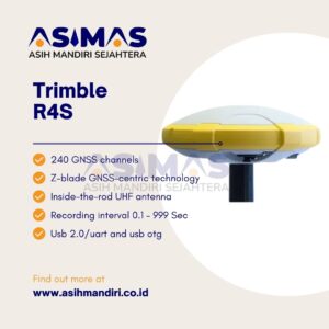
GPS Geodetik Trimble R4S GNSS System

GPS Geodetik Trimble R4S GNSS System terbaru dari Trimble, yang katanya bisa jadi andalan para profesional geospasial.
Namanya Trimble R4s, dan ini bukan main-main, bisa dipakai di berbagai aplikasi dan kondisi, geng.
Jadi begini, rumah receiver-nya itu kuat banget dan tahan banting.
Katanya sih, bisa nahan jatuhnya tiang 2 meter, ini level kesahatan buat alat ukur ya.
Terus, dia punya desain tahan air (IP67),
jadi bisa diandalkan di kondisi luar ruangan yang paling ekstrim sekalipun.
Ada hal menarik nih, guys, di dalam Trimble R4s ini ternyata ada radio UHF 2W internal dan antena di dalam batang yang dipatenkan.
Nah, ini bukan cuma perlindungan buat antenanya,
tapi juga bisa memperluas jangkauan radio RTK. Mantap kan?
Trimble R4s ini juga bisa nerima koreksi dengan akurasi tinggi dari layanan Trimble CenterPoint RTX.
Gimana caranya?
Lewat L-Band dan IP, bro.
Dengan teknologi Z-Blade GNSS-centric, dia punya 240-channel 6G ASIC GNSS board,
ini bikin pengukuran jadi paling andal dan akurat sepanjang masa, di mana pun di dunia.
Diakui nih, spesifikasinya keren abis.
Mulai dari support untuk Trimble RTX real-time correction services, teknologi Z-Blade yang patennya ada,
sampe dukungan buat semua sistem GNSS yang ada di dunia ini.
Ada juga Trimble TSC3 Controller,
Trimble Access field software, dan Trimble Business Center office software,
semuanya buat nemenin kalian di lapangan hingga akhir pekerjaan.
Key Features-nya juga bikin penasaran, kayak high accuracy,
240-channel 6G ASIC GNSS board, Z-blade GNSS-centric technology, SBAS ranging,
Inside-the-rod UHF antenna, Trimble CenterPoint RTX correction service,
Trimble TSC3 Controller, Trimble Access field software, dan Trimble Business Center office software.
Spesifikasi Terbaik GPS Geodetik Trimble R4S GNSS System
Spesifikasinya juga mengesankan, guys.
Ada 240 GNSS channels buat berbagai satelit seperti GPS, GLONASS, BeiDou, Galileo, QZSS, dan SBAS.
Ada juga dukungan buat Trimble RTX real-time correction services, teknologi Z-Blade yang patennya ada,
dan berbagai fitur lain yang bikin pengukuran jadi lebih mantap.
Jadi, kalau kalian lagi cari solusi GNSS yang oke punya,
mungkin Trimble R4s bisa jadi pilihan yang tepat.
Saya saranin nih alat ini GPS Geodetik Trimble R4S GNSS System , cek aja spesifikasinya dan pastiin sesuai dengan kebutuhan kalian, guys!
Spesifikasi GPS Geodetik Trimble R4S GNSS System
| Spesification | 240 GNSS channels – GPS L1C/A, L1P(Y), L2P(Y), L2C – GLONASS L1C/A, L2C/A, L3 – BeiDou B1 (phase 2), B2 – Galileo E1, E5b – QZSS L1C/A, L2C, L1 SAIF – SBAS L1C/A – L-bandSupport for Trimble RTX™real-time correction servicesPatented Z-Blade technology for optimal GNSS performance – Full utilization of signals from all 6 GNSS systems (GPS, GLONASS, BeiDou, Galileo, QZSS and SBAS) – Enhanced GNSS-centric algorithm: fully-independent GNSS signal tracking and optimal data processing, including GPS-only, GLONASS- only or BeiDou-only solution (autonomous to full RTK) – Fast Search engine for quick acquisition and re-acquisition of GNSS signals Patented SBAS ranging for using SBAS code & carrier observations and orbits in RTK processing Patented Strobe™Correlator for reduced GNSS multi-path Up to 10 Hz real-time raw data (code & carrier andposition output) Supported data formats: ATOM, CMR, CMR+, RT CM 2.1, 2.3, 3.0, 3.1 and 3.2 (including MSM), CMRx and sCMRx (rover only) NMEA 0183 messages output |
| REAL TIME ACCURACY1,2 SBAS (WAAS/EGNOS/MSAS/GAGAN) |
Horizontal: < 50 cm
Vertical: < 85 cm |
| Real-Time DGPS position | Horizontal: 25 cm + 1 ppm
Vertical: 50 cm + 1 ppm |
| Real-Time Kinematic position (RTK) | Horizontal: 8 mm + 1 ppm
Vertical: 15 mm + 1 ppm |
| GIS accuracy modes | 30/30 – Horizontal: 30 cm – Vertical: 30 cm7/2 (rmware option needed) – Horizontal: 7 cm – Vertical: 2 cm |
| Real-Time performance | Instant-RTK®Initialization – Typically 2 sec for baselines < 20 km – Up to 99.9% reliabilityRTK initialization range: over 40 km |
POST PROCESSING ACCURACY (RMS) |
|
| Static & Fast static
|
Horizontal: 3 mm + 0.5 ppm
Vertical: 5 mm + 0.5 ppm |
| High-Precision Static3 | Horizontal: 3 mm + 0.1 ppm
Vertical: 3.5 mm + 0.4 ppm |
| Post-Processed Kinematic (PPK) | Horizontal: 8 mm + 1 ppm Vertical: 15 mm + 1 ppm |
DATA LOGGING CHARACTERISTICS
|
|
| Recording interval | Recording interval 0.1 – 999 seconds |
| PHYSICAL CHARACTERISTICS Size |
21 x 21 x 7 cm (8.3 x 8.3 x 2.3 in) |
| Weight | 930 g (2.08 lb) |
| User interface | Five LEDs for Power, Tracking, Bluetooth®, Recording,Radio operations |
| I/O interface | RS232 serial link
USB 2.0/UART and USB OTG Bluetooth 2.1 + EDR. Long range: Class 1 (19 dbm) |
| Memory | 256 MB internal memory NAND Flash
Over a month of 15 sec. raw GNSS data from |
| Operation | RTK rover & base
RTK network rover: VRS, FKP, MAC NTRIP, Direct IP Post-processing Trimble RTX (satellite and cellular/IP) |
| Environmental characteristics | Humidity: 100% condensing
IP67 waterproof, sealed against sand and dust Shocks: MIL STD 810 (g 516.5-10) (01/2000) Vibration : MIL-STD-810F (g 514.5C-17) (01/2000) |
Reviews
There are no reviews yet.