

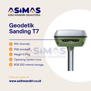
GPS Geodetik Sanding T7

Geodetik Sanding T7 Ini sistem penerima GNSS yang punya fungsi lengkap,
desainnya lebih compact, dan performanya lebih tinggi lagi.
Plus, desainnya kokoh banget buat tahan benturan dan getaran, jadi bisa diandalkan banget.
GPS Geodetic Sanding T7 GNSS Receiver ini bisa melacak sinyal dari semua konstelasi, termasuk sinyal B3 dari satelit BDS.
Nah, yang keren lagi, RTK Sanding T7 ini punya teknologi pengukuran inersia, jadi kita bisa ngelakuin survei kemiringan sampe sudut kemiringan maksimal 60°.
Kita juga gak perlu repot-repot centering, jadi bisa tetep berada dalam posisi yang aman saat ngukur di jalan raya atau gak perlu masuk air.
Fitur Keren Alat GPS Geodetik Sanding T7
- Performa GNSS yang luar biasa
- Tautan radio jarak jauh
- Portabilitas yang paling tinggi
- Pengukuran bebas hambatan
- Desain yang inovatif
- Survei IMU (Opsional)
Jadi, bisa dipastikan, GPS Geodetik Sanding T7 ini adalah pilihan yang tepat buat yang butuh performa tinggi dan kesederhanaan dalam penggunaan.
Spesifikasi GPS Geodetic Sanding T7 GNSS Receiver
| Satellite Signals | |
| Signal tracking | 965 channels |
| GPS: L1, L1C, L2C, L2P, L5 | |
| GLO: G1, G2, G3 | |
| BDS: BDS-2: B1I, B2I, B3I BDS-3: B1I, B3I, B1C, B2a, B2b* | |
| GAL: E1, E5A, E5B, E6C, AltBOC* | |
| QZSS:L1, L2C, L5* | |
| SBAS:L1* | |
| IRNSS:L5* | |
| MSS L-Band(Reserve) | |
| GNSS features | Positioning output rate:1Hz~20Hz |
| Initialization time:<10s | |
| Initialization reliability:>99.99% | |
Positioning precision |
|
| Code differential GNSS positioning | Horizontal: ±0.25m+1ppm Vertical: ±0.50m+1ppm |
| SBAS positioning accuracy: Typically<5m 3DRMS | |
| Static GNSS surveying | H: ±2.5mm+0.5ppm | V: ±5mm+0.5ppm |
| Real-time kinematic surveying | H: ±8mm+1ppm | V: ±15mm+1ppm |
| Network RTK | H: ±8mm+0.5ppm | V: ±15mm+0.5ppm |
| IMU tilt compensation | 10mm + 0.7 mm/° tilt down to 30° |
| IMU tilt angle | 0°~60° |
| User interaction | |
| Operaing system | Linux |
| Buttons | One button operation |
| Indicators | Four indicate lights |
| Web UI | Freely to configure and monitor the receiver by accessing to the web server via Wi-Fi and USB |
| Voice guide | iVoice intelligent voice technology provides status and voice guide |
| Supporting Chinese, English, Korean, Russian, Portuguese, Spanish, Turkish and user define | |
| Secondary development | Providing secondary development package |
Hardware performance |
|
| Dimension | 135mm(Diameter)x84.75mm(Height) |
| Weight | 0.97kg (battery included) |
| Material | Magnesium aluminum alloy shell |
| Operating | -45°C~+70°C |
| Storag | -55°C~+85°C |
| Humidity | 100% Non-condensing |
| Waterproof/Dustproof | IP68 standard, protected from long time immersion to depth of 1m |
| IP68 standard, fully protected against blowing dust | |
| Shock and vibration | Withstand 2 meters pole drop onto the cement ground naturally |
| Power Supply | 9-25V DC, overvoltage protection |
| Battery | Internal Li-on, 6800mAh, 3.7V |
| Battery life | Static mode 10 h, Rover mode 8h,Base mode 8h |
Communications |
|
| I/O port | 5PIN LEMO external power port + RS232, 7PIN external USB(OTG)+Ethernet |
| 1 radio antenna interface | |
| Wireless modem | Built-in radio, 1W/2W/3W switchable, typically work range can be 8KM |
| Radio repeater | |
| Frequency Range | 410-470MHz |
| Communication Protocol | Farlink, Trimtalk450s, SOUTH, HUACE, Hi-target, Satel |
| Double Module Bluetooth | BLEBluetooth 4.0 standard, support for android, ios cellphone connection |
| Bluetooth 2.1 + EDR standard | |
| NFC Communication | Automatic pair between receiver and controller |
| (controller equipped NFC wireless communication module needed) | |
| WIFI | |
| Standard | 802.11 b/g standard |
| WIFI Hotspot | The WIFI hotspot allows any mobile terminal to connect and access to the internal webserver for the control and moditor receiver |
| WIFI data link | To work as the datalink that receiver is able to broadcast and receive differential data via WIFI |
| Data storage/ Transmission | |
| Data Storage | 8GB SSD internal storage |
| Support external USB storage and automatical cycle storage | |
| Changeable record interval, up to 50Hz raw data collection | |
| Data Transmission | USB data transmission, supporting FTP/HTTP data download |
| Data Format | Differential data format: CMR+, CMRx, RTCM 2.1, RTCM 2.3, RTCM 3.0, RTCM 3.1, RTCM 3.2 |
| GPS output data format: NMEA 0183, PJK plane coordinates, Binary code, Trimble GSOF | |
| Network model support: VRS, FKP, MAC, fully support NTRIP protocol | |
| Inertial sensing system | |
| Tilt survey(Optional) | Built-in tilt compensator, correcting coordinates automatically according to the tilt direction and angle of the centering rod |
| Electronic bubble | Controller software display electronic bubble,
checking leveling status of the centering rod real time |
| Thermometer | Built-in thermomter sensors,
adopting intelligent temperature control technology which can monitor and adjust the temperature of receiver in real time |
Reviews
There are no reviews yet.